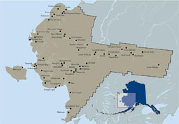
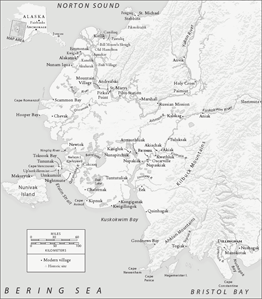
Canineq/Lower Kuskokwim Coastal Area
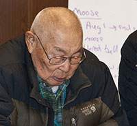
Place name work has a long history in the Canineq area. Born in 1925, John Phillip recalled how in 1971 his own elders encouraged the people of Kongiganak, Tuntutuliak, and Kwigillingok to record place names for their area before they were forgotten. They did this work for the sake of their children, so that they would know the hunting places, fishing sites, and berry picking areas near their homes.
They also wanted young hunters to know the names and locations of sandbars and underwater ocean channels, as well as the dangerous areas they must avoid both on land and sea.
In Kwigillingok, elders Frank Andrew and Paul Slim were invited into the school to help map places in their homeland. Frank Andrew's son, Noah Andrew, and local teacher Denis Ronsi also took students out on the land to visit places close to the village and learn their names. They also encouraged young people to listen to village elders and record their stories.
Learn more
Atrit nalluvkenaki maa-i/They know their names today
 Wangkuta-llu avani augkut wani, augna nunavut ingna piqatallermeggni wangkuta piyugluta pillrunricaaqukut ayagyuaritni, taugaam augkut tegganemta ayagniutellruitkut piunrirpailegmeng, qanerluteng makut wani makunun wangkutnun kinguliarkamtenun-llu wangkuta nallaunritevkaasqelluki makut ayagayarateng wall'u pingnaqsarateng.
Tua-i ava-i map-amek taqulluteng, tamana, elliluki-llu waten tarenrainrilngermegteki makut cat amllerivailgata computer-aat-llu. Wangkuta nunavut unegna ingkut-llu quyurtelartukut waten Qipnermiut, Kuigilngurmiut, Kangirnarmiutangvailgan, Kangirnarmun ataam uterpailemta. Tuani ayagnirluta, 71-aarpailgan wangkuta tamana caliaqellruarput ugna nunavut.
Tua-i-llu ayagniamta taukut qanrulluta, 'Makut wani wangkuta nallunrilkengaput wavet elliluki map-aun tangvagluki map-aq atrit apertuanauput makut kinguliaput pingnaqkuneng tamakut nalluvkenaki pilarniartut, pingnatularniartut.' Neqelget-llu kuiget wall'u nanvat-llu apertualuki tamakut ayagalalteng tekilluki.
Tua-i tamaa-i tamana wangkuta map-aq taqumarian maa-i waten tangvagtelluki waten atrit apertualaraput. Tua-i-llu ilait tan'gaurluut waten murilketalaameng iliini ayagaqameng maa-i waten tamaavet tekitaqameng tuani, tuavet-wa tua-i tekitniluni; atrit nalluvkenaki maa-i.
Cali-llu unani ketemteni imarpigmi unkut qikertaat wangktua qikertaput ketemteni pissurviklallemta qayakun, tamakut cali atrit ellimaluteng unani ketemteni imarpimteni. Tamakut cali nalluvkarpek'naki piaqluki.
Tua-i waten iliini uksuarmi pingnatugaqameng ilateng camek ikayurnarqaqameng, pitarkamek piaqameng, arcaqerluteng makunek asvernek piaqameng ilateng qayagurluki nunat ullagcetlartut tuanetniluteng taum marayam natiini. Nalluvkenaku ullagaqluku tamana.
Quyurrluki elitnaulallruaput tauna map-aq taqngan tamakunek ugkut ayagyuaput. Cali maa-i kinguqliit, tuacetun imkuluki, nallunricesqelluku tamana map-arput taqumalria wangkuta atrit ellimaluki tuani tangvagtelluku piaqluku.
Tua-i tuacetun wangkuta calillruukut, wangkutnek pivkenata. 71-aarpailgan Kangirnarmiutangvailgan wangkuta makut-llu computer-aat tarenrairissuutet alairpailgata tua-i caliaqellruaput. Wangkutnek piyunricaaqluta taugaam augkut ciulirnemta ellaita unayaqluta. Taugaam wiinga-llu tamaani murilketarilua ayagayaurrlua-llu atrit apertuumalriit apaurluma ayagalangvailegma qanrutkelallri-llu elitaqaqluki tua-i augna, augkut ava-i. Tuacetun tua-i, maa-i waten iliini ilaput natmun yuilqumun piluteng piaqameng tamaraqata yuaraaqamegteki  ilateng qayagauraqluki tuavet ellirniluteng.
And those of us out there, when our village [Kongiganak] was going to do [place name mapping], we, their young people didn't choose to do it on our own, but our elders started for us before they died, saying that they wanted us and our future generations to know the places where they travel or subsist.
They made a map, and they put those [place names] down even though they didn't take pictures of the places before many things came around, including computers. Our home area down on the coast, we used to meet along with people from Kipnuk, Kwigillingok before there was the village of Kongiganak, before we returned to Kongiganak. We started during that time, we worked on [mapping] our home area on the coast before 1971 came.
Then, when we started, those people told us, "These things that we know, let's put them down on a map by looking at a map and reveal their names so that when our young people try to subsist they know those places." And places with fish, either rivers or lakes, they revealed those [places] reaching the areas where they used to travel.
Now that the map is done today, having them observe [the map], we reveal their names. And since some of the young men are observant, sometimes when they travel today and they arrive at that place, [a young man] says that he has arrived at that place; they know their names today.
And down below our shore in the ocean, the sandbars down there, our sandbars below our village where we used to hunt with kayaks, the names of those [sandbars] in our ocean down below our village are also on [the map]. We also teach them about those.
Sometimes when they are hunting in the fall, when their fellow people need help with something, when they need help with an animal, especially when they're hunting a walrus, they call their fellow hunters and tell them that they are somewhere around that sandbar. They know that place and go to it.
We used to gather and teach our young people about those places when that map was done. And today, those younger than them, wanting them to know, we have them look at the map with the names on there and teach them about them.
That's how we worked, and not out of our own desire. Before 1971, before the village of Kongiganak was established, and before these computers that take images came around, we worked on it. We weren't the ones who wanted to, but our elders asked us to work with them. But during that time, I had become observant and had started to travel, the names that were revealed and the names that my grandfather mentioned before I started to travel, I'd recognize them. That's how, when our fellow villagers travel to the wilderness and get lost, when [people] search for them, they call their fellow people and say that they have reached that particular place.
John Phillip, Kongiganak

To this day, Canineq elders talk to their young people, encouraging them to continue to use traditional place names and to pass them on.
Between 2016 and 2018 we were able to work with elders from Kuskokwim communities below Bethel. Once again, elders generously shared place names and stories from their region. These elders included Alexie Nicholai, Ignaty Jacob, and Nicholai Steven of Oscarville; Fannie Jacob, Nastasia Larson, Yako Andrew, Chris Larson, Martha Evan, Noah Okoviak, Marie Andrew, Nicholas Evan, James and Mildred Nicholai, and Elizabeth Stevens of Napaskiak; and George Billy, Annie Nelson, Jacob Black, George Berry, and Ralph Nelson of Napakiak.
Since 2018, CEC staff has also had the opportunity to work with a number of men and women in upriver Kuskokwim communities, including John Andrew and Joe Spein from Kwethluk; Peter Gilila from Akiak; Michael Savage, George Morgan, Bob Aloysius, and Elena Sergie of Kalskag; Clara Morgan, Olga Peterson, and Agnes Andreanoff of Aniak; Sophie Sakar, Nastasia Avakumoff, Lucy Simeon, and Eric Morgan of Chuathbaluk; Angie Kameroff of Sleetmute; and Jennie Zaukar and Wassily Kameroff, presently living in Anchorage. Thanks to these elders, we have been able to add hundreds of place names, stories, and historic photos from the Kuskokwim River and its tributaries to the Yup'ik Atlas.


